|
| |
 Burwash Common in East Sussex is a village with an identity crisis,
to the west when coming into the village from
Heathfield it is signposted as Burwash Common , and
when coming in from Burwash it is signposted as
Burwash Weald . It is made up of the two hamlets,
but because they overlap, the East Sussex County
council decided not to put up two additional signs
to define the hamlets. Burwash Common in East Sussex is a village with an identity crisis,
to the west when coming into the village from
Heathfield it is signposted as Burwash Common , and
when coming in from Burwash it is signposted as
Burwash Weald . It is made up of the two hamlets,
but because they overlap, the East Sussex County
council decided not to put up two additional signs
to define the hamlets.
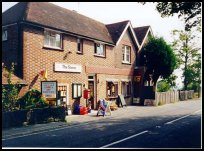
Burwash Weald was originally the hamlet called Burwash Wheel
after its first pub which was probably called the
'Catherine Wheel' after Catherine of Aragon, who was Henry VIII's
first wife in 1509. The original building which became the first
pub was built in the thirteenth century but was later converted
to a poor house, when the present pub was built about 1760. At
about the same time the hamlet was renamed Burwash Weald as the
church commissioners did not feel it was appropriate to have their
poorhouse in a location named after a pub.
An episode that is recorded at the Wheel in September 1788 when Mr
Pudsey, a revenue officer, siezed 15 casks of foreign spirits and
deposited them in the stables of the pub. The smugglers attempted
to retake the contraband and Mr Pudsey was forced to shoot one of
them in the arm before gaining assistance from a peace officer and
securing his siezure.
In the 1830s the whole area was plagued with gangs of smugglers
and criminals with the bulk of the inhabitants considered to be
ignorant and lawless, although gradually the hamlet was becoming
more a service area on a main route between the south east, south
and south west. It is reported that around 1834 as far away as
Portsmouth people spoke of the Wheel as the roughest public house
they had ever been in. (Many thanks to Bob &
Sylvia from The Wheel Inn for providing the above
information)
The Catherine Wheel depicted on the inn sign came
from the coat of arms of the 11th Century Knights
of St Catherine of Sinai, who aided travellers.
At the bottom of the Dudwell valley was the old forge,
which from the late 1500's made implements from pig iron
produced in the area. From the 1750's much of the iron
came from the nearby Heathfield furnace which was owned
by the Fuller family of Brightling . The forge stopped
production in the early parts of the 1800's.
Because the area was in the centre of the Wealden Iron
Industry, which declined in the early 19th century,
due to competition from the North of England, and their
coal fired furnaces, the local unemployed took to
smuggling and highway robbery. In 1869 Mr Trower
wrote that it was unsafe to travel along the
Heathfield turnpike between 1820 and 1840 for fear
of robbery from vagrants.
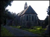
The church of St Philip's was built in 1867, in the
area originally known as the Common. In 1877 the
Common and Wheel were formed into a parish. Prior
to this date, the area was in the parish of Burwash . |
|
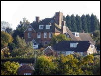
 Burwash Common in East Sussex has some very pretty views of the
surrounding area.
To the north down the Stonegate road can be seen
the Rother Valley. Burwash Common in East Sussex has some very pretty views of the
surrounding area.
To the north down the Stonegate road can be seen
the Rother Valley.
From Burwash Weald, look south towards Brightling
Needle. |
|
 Burwash Common in East Sussex has limited services, however a
public house is in Burwash Weald . Burwash Common in East Sussex has limited services, however a
public house is in Burwash Weald .
The main shopping centre for Burwash Common is the
small town of Heathfield about 5 miles west. The
nearest large town shopping centres are in Hastings
about 13 miles South East, and Tunbridge Wells 14
miles to the North.
An infrequent bus service stops in the village and
travels to Heathfield and Hurst Green for further
connections.
The nearest train services are available from
Etchingham 4 miles to the east, or Stonegate
about 5 miles north. |
|
| Burwash Common is shown as the red symbol on the map. |
|
|
Nearby Villages
(click on symbol to see the village page) |
| Village= | |
Town= | |
Recorded in Domesday= |  |
| |
|
|
Brightling |
(famous for Mad Jack Fuller) | | 2.89 miles |
|
|
Broad Oak |
(Smallpox at the Academy) | | 2.43 miles |
|
|
Burwash |
(The home of Rudyard Kipling) | | 2.30 miles |
|
|
Burwash Weald |
(Roughest pub in the South East) | | 0.44 miles |
|
|
Cade Street |
(Jack Cade and the Kentish rebellion) | | 2.79 miles |
|
|
Cross in Hand |
(The Crusaders Assembly) | | 5.20 miles |
|
|
Dallington |
(Custers Last Stand!) | | 2.68 miles |
|
|
Etchingham |
(The oldest Brass Weather Vane in the country) | | 4.61 miles |
|
|
Five Ashes |
(Vast collection of rock plants) | | 5.47 miles |
|
|
Heathfield |
(19th Century Natural Gas) | | 3.91 miles |
|
|
Horam |
(Which Station do we get off at ?) | | 5.54 miles |
|
|
Hurst Green |
(The Youngest Highwayman on record) | | 6.08 miles |
|
|
Mayfield |
(Saint Dunstan and the Devil) | | 4.28 miles |
|
|
Mountfield |
(17th Century Coal !!) | | 6.37 miles |
|
|
Netherfield |
(Village at the top of the Hill) | | 4.94 miles |
|
|
Punnetts Town |
(The Windmill on the Hill) | | 1.91 miles |
|
|
Robertsbridge |
(The Home of Modern Cricket) | | 5.76 miles |
|
|
Rushlake Green |
(Open Village and Nuclear Bunker) | | 3.11 miles |
|
|
Salehurst |
(Richard the Lion Heart's Gift) | | 6.56 miles |
|
|
Stonegate |
(Ancient Roman Cross Road) | | 3.72 miles |
|
|
Vines Cross |
(Cannons and Doodlebugs) | | 4.61 miles |
|
|
Waldron |
(Fullers Earth) | | 6.39 miles |
|
|
Warbleton |
(The Iron Man) | | 3.81 miles |
|
|


